Thursday, November 30, 2006

Week 35 (20th - 26th November)

We took the Overlander’s Way, originally built as a Cobb & Co. coach route and served as an important supply line during World War II. After putting Townsville well behind us the countryside grew steadily flatter and drier and, as crows put in their appearance once more pecking at bloated kangaroos lying dead by the roadside, we could not help reflecting on the joys of the luxuriant rain forests we had left behind. Although Roger’s comment “rain forests are dripping wet with no view” made us smile and ponder another opinion as we were overtaken by road train after road train.
Our first night was spent alongside the dry bed of the Campaspe River, sandwiched between the railway bridge and the road bridge in a well shaded spot with plenty of bird life flitting between the riverine trees. A distant clinking struck a chord in Lea’s memory of a windmill and as evening came George took a walk up the river bed and found the old metal windmill dribbling water into a rusty tank, a good few leaks to supply water to some grateful birds and kangaroos.

509km covered on Tuesday! Not because we wanted to but simply because the miles and miles of scrub and grassland utilised as cattle stations that stretched out in all directions around us, afforded no decent rest area. Even in the little communities along the route we couldn’t bring ourselves to pay for a caravan park where the sun beat down mercilessly and looked little better than the rest areas. And so our mileage crept up … The long day’s travel was broken by the interest that began developing on our arrival in Hughenden, to find “Mutt” the life-sized replica of a Muttaburrasaurus standing on a street corner. We discovered that we were travelling across a vast prehistoric inland sea rich in marine fossils. Sculptures by local artists depicting an ammonite, a pterosaur and “Darby” the dinosaur caught our eyes with the ingenious use of scrap metal. We were also most taken by a windmill rotunda we found in the middle of a wide street. Queensland seems to like the use of the word “rotunda” as we’ve seen it often and take it to mean a round meeting place.


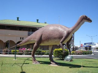
Mutt the Muttaburrasaurus in Hughenden

U Think They Saurus … was followed by a moments hesitation before it tickled our imaginations. This was the first of several signs about Kronosaurus Korner as we approached Richmond which proclaims to be the fossil capital of Australia. We decided we had to visit a place with such a quirky sense of humour. First we needed our lunch and the Lions Park fitted the bill with its green lawn and a place to park in the town centre. We noticed the edging of the lawn and a commemorative cairn had been made of strange round rocks. During our visit to Kronosaurus Korner we discovered these nodules are a unique feature to the Richmond Shire and are appropriately known as moon rocks. Richmond hosts a bi-annual moon rock throwing competition – shows how many of these moon shaped rocks are around. Cartoon-ish sounding Kronosaurus Korner turned out to be an exceptionally interesting and well presented marine fossil museum containing the remains of the Richmond pliosaur (the best preserved skeleton in the world), ichthyosaurs, the dinosaur (Minmi – preserved so well that even part of its stomach contents were intact) and Kronosaurus – the largest marine reptile to ever live, so huge, with teeth the size of bananas, that he could have eaten T. rex for breakfast.


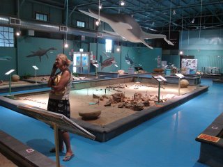
Kronosaurus Korner - marine fossil museum at Richmond
Back we went to the uneven, patched up, and “make do” road which needed all one’s concentration, all not helped by driving due west into the setting sun with temperatures of 40°C. Unable to shield our eyes any longer we abruptly pulled off into a clearing that suddenly materialised, determined to go no further! What a haven it turned out to be, apart from the flies which we didn’t have to suffer long, as night was almost upon us.

The worst section of the Overlander’s Way, best described as forgettable landscape, appeared to be over by the next day once we reached Cloncurry. Thereafter we meandered our way through the Selwyn Ranges with its dramatic rocky outcrops. One in particular looked like it was out of a cowboy movie with black kites circling above it in vulture fashion. Spinifex was back covering the foot slopes and, on a road that was decidedly better than yesterday, we made good time to Mt. Isa.
This statement appears in The Isa Visitor’s Guide welcome … “Mt Isa is one of the largest cities in the world, covering an area the size of Switzerland and with a main street 180km long!” We had to check this out as George could not credit it.
We took a ride around town as we wanted to see the underground hospital and the National Trust tent house, a style of house unique to Mt Isa in the early 1930’s, only to find all tourist attractions close at the end of September. Only mad dogs and ….. go out in this noonday sun! The “huge” city was done in next to no time and stopping at the Outback at Isa complex we established that the reason Mt Isa was once listed in the Guinness Book of Records as being the largest city with the longest main street is earned on a technicality. The Shire boundaries form the “city” and Camooweal, a “suburb” 180km away, falls under the jurisdiction of Mt Isa. Clearly, it’s nothing but a publicity ploy. An extra day was spent in Mt Isa in order for Skiv to have an oil change while Lea got our laundry done.

We were sweltering before we even pulled out of our caravan park for Camooweal on Friday. Casting an eye at our temperature gauge, reading 38°C so early in the day, we wondered where it would be by midday. Camooweal was nothing to shout about and with the thermometer steadily rising we wanted to put as much mileage as possible behind us. 13km further we crossed back into the Northern Territory to be surrounded by seas of sun-bleached yellow grass stretching to the horizon, a shimmering black road, edged in red soil that had been scraped clear of vegetation, lay endlessly before us. This was the Berkeley Tablelands, with warnings about cross winds and headwinds and no fuel for hundreds of kilometres. In the distance trees mirages danced and, under one scraggly shrub, cattle huddled together believing they were in shade. No windmills, no waterholes, dry creeks and river-beds, left us gulping down water and wondering how they survive. Through the heat haze we began to see grey columns rising and dissipating. These “cock-eyed bobs” (whirlwinds) became clearer as we passed through burnt out land and in one spot we had a heart-stopping moment when one engulfed us, sending us lurching sideways. We’d had enough of the western sun streaming directly into the cab and hot air blasting through the windows that when Berkeley Homestead offered shady, lawned sites we couldn’t resist this oasis. We flew out of Skiv into their swimming pool and wallowed for a good hour watching a truckie fastidiously polish all the chrome on his gigantic “mean machine”. Later a mud lark hopped into the caravan and checked out the floor as we sat mesmerised by our little guest. The sound of the Homestead’s generator beating away rhythmically and the warm air clinging to us, we felt as if we could have been in Beit Bridge as we tried to sleep.

More of the same next day as we as we completed the Overlander’s Way passing through huge tracts of sunburnt land. The heat drained us of conversation. At one time Lea leant back and said she had to think of England in a desperate effort to ‘feel’ cool when, lo and behold, against the expanse of blue sky appeared a streak of vapour trail, very much like the criss-crossed jet streams of NE Lincolnshire skies. Turning south on joining the Stuart Highway our hearts sank at the sight of another substantial distance to be covered across Central Australia in these high temperatures. We re-fueled in Tennant Creek and made haste for Devil’s Marbles Conservation Reserve where we thought we’d spend the night. Running parallel to the Stuart Highway the telephone line prompted George to babble on about the epic construction of the original overland telegraph line. Completed in 1872 it ended Australia’s communication isolation from the rest of the world when a single strand of wire was strung across the country from Darwin to Port Augusta. The 3200 km long line, built through the most inhospitable terrain with the aid of camels bringing in the poles – no less than 20 for every mile - connected Australia to a submarine cable from England. Lea retorted “so much for communication in 2007 when our mobiles are operational over only 12% of the country”. Just as well we arrived at the Devil’s Marbles and were distracted by the huge rounded boulders. Aboriginal dreamtime legend describes them as eggs of the Rainbow Serpent. Geo-morphologists use the term “cheeserings” because they resemble flattish lumps of cheese. The name Devil’s Marbles appears to date back to a description of the place when laying the telegraph line back in 1871. Lea thought The Cheese Factory would be just as suitable.

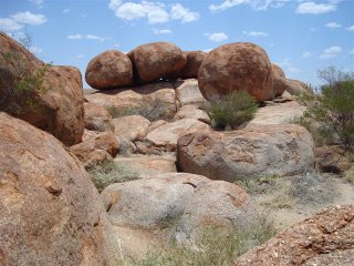
Rounded granite boulders - Devil's Marbles

With barely any shade in the campsite and the reflected heat off the granite, by the time we had finished our lunch we knew we’d been there long enough!
Next place on the map was Wycliffe Well, supposedly the UFO capital of Australia. Hitch-hiker Ed had told us about this place so our interest was piqued. We were startled to find a “Big Four” here, more so that this upmarket caravan park could have derelict cars, litter and beer cans strewn everywhere on its border. We could only believe a UFO had created this havoc! We passed on this overnight accommodation too.

Approaching Barrow Creek – our imaginations and curiosity came into play as this was the site of Peter Falconio’s murder and Joanne Lees’s escape that generated an intense man hunt in July 2001 with enormous media attention worldwide. During long hours on the road we have chewed over this case time and again with Paul, Saxon and Paula, as each of us completed reading Richard Shear’s book “Bloodstain – the vanishing of Peter Falconio”. Just as well it was a dark night as the bush where Joanne hid is very scanty and what she must have thought when her truckie rescuers took her to the Barrow Creek Hotel heaven knows as we were shocked by this seedy place. In comparison to the well kept historic Telegraph Repeater Station there, the hotel looked ram-shackled and down-at- the-heels, its “caravan park” awful.

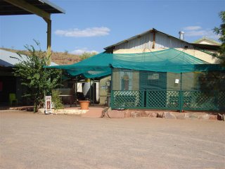
Barrow Creek Hotel (Joanne Lees brought here by truckies)

Eventually clocking up 560km to our day, we came to roost up for the night in Prowse Gap rest area. Got the generator going and caught up on our blog with mighty “King of the Roads” thundering past, all lit up like Christmas trees.
Soon after hitting the road on Sunday morning we came to the turn off to Aileron with its queer sign BIG MAN WALKING. We turned in to see what it was about and immediately spotted the statue of the big man standing proud on top of the hill. There was nothing around to explain its origins or that of the enclosures outside the pub with a dingo, an emu and a young camel within. Following the short loop road back to the Stuart Highway the surrounds of a “sociable” tree caught our eye with its broken bottles and beer cans blighting the landscape. In fact, much of the wide roadsides of the Stuart Highway, from Tennant Creek to Alice, glittered with wine sacks, aluminium cans, glass and plastic bottles along with beer cartons, plastic bags, car tyres and a higher than normal amount of discarded (stolen?) vehicles. Ironically, the entrances to communities were thick with beer cans despite large signs warning of liquor prohibition beyond that point. Not only does it show appalling disregard for hiding the evidence but it is also a dreadful indictment of the degradation of self and country.

After the long, flat route with little relief in the form of high ground the sense of arrival in Alice Springs was heightened by its rocky, broken terrain that took us into the city. We booked into a very central caravan park, turned on the air conditioning and recovered from our journey, pleased to have arrived in the centre of Australia!

Sunday, November 19, 2006

Week 34 (11th - 19th November)

Rain began falling in the early hours of Saturday morning, the first good thumping we’ve heard on Getaway since crossing the Nullarbor. By breakfast we were having intermittent showers and the mountains around us were shrouded in cloud. We hoped that in departing we’d leave the wet behind us and thankfully that happened. We made Brampton Beach, 80km south of Cairns, in good time to select a beach side site for ourselves. An anti-stinger enclosure enabled us to have our first swim in the Coral Sea. Not the colour we would have chosen to swim in, with waves churning up sand or so we thought, until we entered the warm water. As we went deeper we became aware of currents of chilly bottom waters and realised it wasn’t sand being churned up by the waves to give the sea its turbid colour, but suspended clay. This lead us to think about the many man-induced problems that the corals of the Great Barrier Reef currently face – from sediment deposition to nutrient enrichment, not to mention coral bleaching due to global warming. Just days ago we heard on TV that some-one had proposed the government should give serious consideration to either covering the reef with shade cloth or pumping in cold water from deep offshore to alleviate the warming!

The caravan parks at both Wonga and Brampton beaches are municipally run and occupy prime beachfront positions within the coastal reserve making them very desirable in our eyes. Generally, all developments are kept well behind the foreshore with the road in front of them. That evening as we walked to the point of Brampton Beach we observed how many residents leave their outdoor furniture on the high water mark to avoid carrying it all back over the reserve that prevents them from truly having beach frontage properties.

With lots to see on the Great Green Way and November disappearing fast we didn’t tarry longer than 24 hours at Brampton Beach. In departing we noticed some of the damage caused by Cyclone Larry on the sea-facing slopes of the mountains. The many denuded / coppicing trees reminding us that we were approaching the area that had been in the eye of it all. We saw our first trains transporting sugar cane which jolted us because we hadn’t seen any cane suitable for harvesting as yet. The cane size in the many fields we had passed through looked immature in comparison to Natal cane at harvest time. All the trucks appeared to be carrying cane chopped to a size that made it look almost trashy. We need our cane farmer friend Raymond to advise us on our perceptions. As we neared Innisfail the banana plantations that Cyclone Larry had decimated earlier this year came into view. The differing stages of maturity on the plantations, lack of bags protecting bunches and empty road stalls made us wonder how long Cyclone Larry will hold Australia to ransom over a banana.

“Nothing compares - wander through the captivating charm of a lost castle of romantic dreams, inspired by spectacular waterfalls and nestled in the lush tranquillity of a mysterious rain forest. Delightful gardens whisper untold stories of the past”. So read the advert for Paronella Park that captured our interest. In 1993 Mark and Judy Evans, a Western Australian couple, bought a derelict, overgrown property on Mena Creek that over the years had been hammered by floods, cyclones and fire. The property had a history dating back to 1929 when it was built out of virgin rain forest by a Spanish dreamer, Jose Paronella. A baker by trade, he came to Australia in 1913 to seek his fortune and, by working and saving hard for 11 years, amassed a fortune buying, improving and selling cane farms. Romantic Jose returned to Spain to collect his fiancée only, he’d neglected to make contact over all the years and she’d married another. Undeterred he married a younger sister and returned to Australia to begin building the castle of his childhood dreams.

Refreshment rooms - Paronella Park

Such was his vision, ingenuity and capacity for hard work he achieved all that and more. His artistic abilities came to the fore when creating not only a home for his family but also an entertainment centre way ahead of its time. Besides using the waterfall on Mena Creek as a focal point to his property he put in a hydro electric generating plant providing power for his development 15 years before anyone else in the region had electricity. His castle with cinema, ballroom, tennis courts and magnificent landscaped gardens opened to the public in 1935. This visionary with his appreciation for beauty and fine hospitality died in 1948. A succession of catastrophe’s followed that all but obliterated Patronella Park. Years later the Evans couple discovered the shattered pieces of Jose Patronella’s dream as they cut back the jungle of their newly acquired property. Amazingly Jose’s daughter, now in her eighties, came to light and with her help they have set out to reinvent Jose’s legacy to tourism.

Arriving at Paronella Park we had in mind a stately home a la England not a strange little village scene. All was to be revealed in a series of leisurely tours throughout the day by enthusiastic guides taking us over the heritage listed remnants of the castle and gardens which are largely concealed from view yet cover 13 acres. We stayed in their little caravan park on top of the hill which enabled us to take advantage of all the tours at times to suit ourselves for a one-off entry price. The local Aboriginals sharing their traditional knowledge of bush tucker and indigenous dances proved shining examples of how well their own initiatives can be incorporated into a tourist based business.

The finale to our day at Paronella Park was the “Darkness Falls Tour” taken at evening time. Without the sun beating down mercilessly through the enormous gaps in the forest canopy left by the latest cyclone we were able to wander through gardens changed by the soft and fast falling light, the presence of fire-flies, bats and birds in flight adding their mystique. From the many avenues we had glimpses of the Mena Creek Falls which Cyclone Larry had inadvertently exposed bringing back Jose’s original intention. As we stood in the dark on the old tennis courts looking through an archway in a timeless old building that framed the falls, in true Jose Paronella style, its form was suddenly illuminated to divulge a lone saxophonist on the upper tower playing a haunting tune … thus “continuing his dream”.

Trailing back down to the coast and along Mission Beach, we made our next stop at Wongaling Beach overlooking Dunk Island. A no swimming beach which was a pity as the water was a lovely colour. We made do with walking and noticed that the beach profile was in the process of being mechanically reshaped to protect the mass of exposed roots along the edge of the beach reserve. Not a good beachfront management practice as their efforts to cure one problem will almost certainly lead to another.

Tully interested us because on our arrival in Ravenshoe four weeks ago in cold, drizzly weather we’d looked at a “rain pole” topped by Tully, the wettest place in Australia! The next town on our map was Tully so we called in there for fresh bread and milk. In the park we found the 7.9m high gumboot commemorating Tully’s place in Australian records as the town with the heaviest annual rainfall ever recorded.


7.9m high (annual rainfall) big gumboot at Tully

We have been zigzagging between coastal and mountainous habitats of late – After Wongaling beach it was up to the Murray River National Park. Parking Getaway within earshot of the 30m high Murray Falls we set up camp and spent the day reviving from the heat by taking regular dips in the crystal clear rock pools AND clopping march flies! Related to horseflies these sluggish blood suckers fortunately seemed to prefer men here. The “March Dance” as we came to call it is somewhat like the South African gum boot dance. In this case very amusing as the stamping and slapping occurs so unexpectedly. By nightfall we were the only ones left in the National Park. In the silence we hoped we’d see some night creatures but, other than fire flies flitting between the lofty trees around us we received no company.

Back to the coast! We made for Cardwell and Hinchinbrook Island – the caravan parks were well back from the beach and not appealing to us. We hoped Lucinda would be better so continued on there in time for lunch. Driving through the massive swamps of the Herbert Estuary a strong on shore wind began developing- cooled us down but wasn’t pleasant for beach walking. It wasn’t a wasted journey though as the world’s longest sugar loading jetty is here and George was keen to see that.
Found ourselves a shady spot to eat our lunch overlooking the sugar facility and the southern end of Hitchinbrook Island with Mt Bowen towering in the background. This mountain changed the life of Warren Macdonald in 1997, while climbing Mt Bowen, the highest of the many peaks on this rugged island. A freakish accident occurred when a massive slab of rock sheared off the mountain trapping him for two days and nights in a creek bed. He wrote an inspiring story “A Test of Will” about the dramatic rescue that followed and his determination to overcome the handicap of having both legs amputated. We, as readers were overwhelmed by his courage.

5.7km sugar loading facility at Lucinda and stinger net at Lucinda, with deep water berth & Mt Bowen on Hinchinbrook Island in background

The strength of the wind drove us inland to Ingham for the night. After carefully selecting our site and unhitching well away from the main road we were horrified when a train rumbled past within a stone’s throw of our doorstep! We are still bemused that we didn’t see that line especially as George had just remarked what a beautiful farm-like setting we had with cows lowing in the meadows and chickens scratching around!

The road to Girringun National Park was considered unsuitable for buses and caravans. As we were keen to see the Wallaman Falls (the highest single drop falls in Australia) we left Getaway in camp and drove across the cane covered flats and up the steep, winding road climbing to 540m above sea level where we found the spectacular falls. Plunging 268m into the valley of the Herbert River it made a very glamorous bridal veil with a rainbow catching the light within the spray. March flies irritated the hell out of George as he tried to capture the falls on camera.

268m high Wallaman Falls, Girringun NP. The highest single drop falls in Australia

Half way down the access road was a lovely view spot overlooking the Herbert River Gorge. No sooner had we stopped for lunch there than we heard a strange alarm and up the hill and into our lookout came an overheated VW Wicked , out of which sprang two Irish guys, very agitated about their hire vehicle and worrying about how much further the falls were. We had a good chat while their engine cooled. By now the coastal lowlands were scarcely visible, obscured by a heat or smoke haze. Returning to Ingham the ferocity of the heat hit us. On the news that evening we learnt that the temperatures had reached 36°C. After cold showers we sat in the shade of Getaway and noticed a tiny sunbird building its nest from spider webs in a spindly shrub a metre from us. So much effort in a position that is far from safe!

With a selection of 48 hour beachside rest areas available between Ingham & Townsville we took a look at each one until we arrived at the last- Saunders Beach where we had to stay. Fortunately it turned out to be the best. Having left the rainforests behind us we are finding the landscape very hot and dry looking. With strong on shore winds persisting we were kept well entertained by kite boarding enthusiasts who’d been drawn by the wind, forsaking their jobs for the afternoon. Just like Daniel, they were racing up and down through the waves, leaping into the air with twists and somersaults periodically crashing out in the shallows. After a shark had been spotted amongst them, George was asked to keep a lookout for the black fin.

On Saturday morning we drove into Townsville taking up a caravan site on the outskirts of the city. Spent the rest of the morning on The Strand where we happened upon the Tobruk swimming pool. Arising from our enquiries at the desk our sleuthing paid dividends. Amazingly, within the hour we had Roger Lebish on the line. An old friend from our Kariba days, we arranged to meet that night when he had finished his voluntary Coast Guard work. We had such a disturbed night with big trucks and trains rumbling past all night that in the morning we packed up and moved to Rowes Bay caravan park ideally situated to joining Roger and Judy in the late afternoon for a walk and dinner at their place. The Sunday markets lured us into the city for the rest of the morning where we brought some fresh tropical fruits to savour as we begin the hot, dry crossing back over the continent en route for Western Australia.

From here on it’s goodbye to the cool sea breezes and humidity which we prefer.

Sunday, November 12, 2006

Week 33 (5th - 10th November)

Whoa! Curiosity will kill the cats - Wonga Beach has helped break the habit of needing to see around the next corner. This place must be one of the best kept secrets in Australia and definitely a place to return to one day.
We drove through to Port Douglas for their Sunday market. Expecting something of a concrete jungle we found a very tasteful town steeped in lush tropical gardens and trees, set at the end of a small peninsula to give it an island feel. Adding to the vistas across the sea were the ever present mountains of the Great Divide. When our feet were sore from all the walking we found respite on 4 Mile Beach and had our picnic. Interesting to find a stinger barrier net in place for the cautious!
That night we watched the film “Seabiscuit” on TV. Afterwards, we found the full moon out in all her glory. All thoughts of bed fell by the wayside as we stepped onto our beach and took a long walk in its silvery light. On our return, a documentary on Grace Kelly caught our attention and we were immediately engrossed as it covered all the places we went to while in Monaco last year. Awaking next morning we knew we couldn’t leave here and stayed just one more night.

On Melbourne Cup Day when the whole of Australia comes to a standstill for a horse race we rolled out of Wonga Beach for Cairns. The Captain Cook Highway turned out to be most scenic route particularly over a 28km stretch that hugged the coastline south of Port Douglas as it cut through a section of the Wet Tropics World Heritage Area. Nearing the outskirts of Cairns we turned towards the Barron Gorge National Park and booked into Lake Placid Caravan Park. After an early lunch we shot into the city to find Sea Swift, the shipping company that offers trips to Cape York aboard a working cargo vessel, the MV Trinity Bay. We asked directions at the Visitor’s Information centre and gained the impression it was “just down the road”. We walked! We walked and walked in the hottest time of the day, with the sun eating into our skin, no shady side to the road, through industrial dockside areas with nothing even to look at en route, arrived as red as beetroots only to find they were fully booked to the end of the month. At least going we had anticipation, returning we had nothing but sore feet. Disappointed that we weren’t going to make the top of Cape York and the Torres Strait Islands we decided we’d travel the legendary rail route to Kuranda and come back on the Skyrail and made our booking for the next day. On our homeward journey the breathalyser teams were out in force checking Melbourne Cup revellers.

“FORTITUDE, SWEAT AND BARE HANDS … our journey didn’t come easy!” This rail line is an incredible feat considering the terrain traversed. Constructed by hand with basic tools and dynamite over the period 1886 - 1891 through dense jungle, over deep ravines, narrowly skirting cliffs with drops of hundreds of metres and across 45° slopes, these pioneers formed 15 tunnels, dozens of bridges and kilometres of track. From the moment we stepped into the charming past of Freshwater Station to await the arrival of the train we knew we were in for something good. The brightly coloured diesel engine seemed almost alien on arrival, but climbing into the carriage returned us to those early days of Puffing Billies. Once we set off the clickety-clack and swaying motion transported us back to the years of train travel we did in our youth. No time to reminisce as the cane-fields of the coastal lowlands rapidly dropped away and we began a slow spectacular climb up to the Tablelands we’d left two weeks ago. We have seen many faces to the Barron River from its source to the sea, including its impoundment at Lake Tinaroo. Now we were threading our way around the side of the Barron Gorge, sneaking past the Stony Creek falls on an iron lattice bridge (the most outstanding feature of the rail line) and, as we neared Kuranda, the train stopped to allow us all to stretch legs and look down from view points at the 265m high Barron Falls. This height is put to good use for hydropower.

Scenic Railway to Kuranda. Stony creek falls in background


Heritage listed for its Federation style Kuranda station was not only a perfect ending to the journey but also a fine introduction to a showcase village in the rain forest. Shady ramps through landscaped surrounds eased the gradient up to the main street lined with markets, shops and al fresco dining outlets provide for the thousands of tourists that pass through here annually. Banyan figs festooned with roots added to the picturesque street scene and we were impressed by the attention to detail with a sculpted look given to rubbish bins, bollards and direction signs. Unless you were looking it was easy to miss the leaves, frogs, praying mantis or lizards that had been subtly added.

Banyan figs - Kuranda street scene


By the afternoon with our feet feeling the effects of yesterday we’d had enough walking and sauntered down to the Skyrail Cableway only to be stopped in our tracks by an electric blue flash and a simultaneous yell of delight from George – a Ulysses swallowtail made a brief appearance before our eyes. As a lad George had been a mad keen butterfly collector and despite the years, the excitement of seeing this beauty, was still exhilarating. He saw another two before the afternoon was out. Man oh man! For another perspective of rain forest there is nothing to beat being suspended in a gondola. We had the most stunning panoramic views gliding (with some juddering) just metres above the rain forest canopy for 7.5km. The Skyrail stops twice on its way to the bottom providing an opportunity to visit their Interpretation Centre, lookouts onto the Barron Falls from the opposite side to the rail line and boardwalks through the lush surroundings.


Skyrail cableway


Our bird’s eye view of the rugged mountains, steep ravines and tumbling waterfalls with tropical forests stretching as far as the eye could see was unbelievable. Finally, as we dropped over sea facing slope of the Great Divide came a mosaic made up of the coastal flats, the satellite suburbs of Cairns and the Coral Sea. This day’s experience surpassed all expectations and we very nearly missed it in favour of a trip on a cargo vessel.

On the doorstep of our caravan park the Barron River flows past. Further up it forms a large natural pool known as Lake Placid. Escaping from Getaway’s hot, shade-less surrounds we packed a picnic intending to spend the morning alongside this popular croc/stinger free swimming spot. Although an attractive place we found it a little too cramped for our liking and drove up the gorge hoping to find a suitable spot but ended up at the hydro station. Here we spent an informative hour chatting to the old chap running the visitors centre. He had been involved in this scheme and others in Queensland for a good twenty years. Acting on his advice we drove to Lake Morris, the water supply dam for the city of Cairns. To our confusion it was sign posted as Copperlode Dam. Nevertheless we took the steep, narrow, winding road all the way up to a beautiful artificial lake, surrounded by rain forest, in the mountains 20km from Cairns. In a thoughtfully laid out picnic site overlooking the dam, with a likeness to a Scottish loch, we were able to have our lunch watching a grey cloud come over the mountain, darken the waters and shower the valley with rain. We weren’t affected thanks to the roof over each picnic table which allowed us to enjoy the welcome coolness, the smell of damp earth and the contrasting play of sunlight as the clouds rolled around the mountain tops.


Lake Morris - Copperlode dam

Two plaques attached to a rock near us declared Lake Morris had been named after the City Engineer who’d identified the suitability of the site for water storage (1935-37), and the other gave the name Copperlode Falls dam (1976) so we were no wiser as to the distinction.

Saturday, we leave Cairns to follow The Great Green Way down to Townsville. We will no doubt spend the best part of next week at the many little places en route. The Wet Tropics World Heritage Area, incorporating 733 separate parcels of land continues to spread South of Cairns providing us with plenty more to see.

Sunday, November 05, 2006

Week 32 (29th October - 4th November)

Travel day – making for the north, with no end destination in mind, we left our familiar Wet Tropics rain forests and patchwork pastures of dairy cows behind. At Tolga we began finding the fruit and vegetable stalls and produce farms that we’d expected to see far sooner, or was that wishful thinking when we came out of the parched outback. Back on the Savannah Way with its characteristically dry eucalypt woodlands we passed the canal carrying water from Lake Tinaroo and encountered plantations of coffee, litchis, bananas, avocadoes and macadamia nuts all the way through to Mareeba. Just outside Mt Molloy we stopped at a 48hr rest area and contemplated staying in this obviously popular, well kept “up-market” bush camp, cold showers and all. However, with the sun beating down, we felt it was too soon in the day to halt and the lure of the coast had more appeal. Climbing towards the mountains neatly manicured tea plantations appeared and then we were back in our rain forests.

Life is breathtaking experiences! Rounding a corner on the crest of the Mossman Bluff we came upon an unexpectedly beautiful window in the forest giving us our first view of the translucent Coral Sea, its steep, forested coastline, off shore islands and the Great Barrier Reef. In low gear we wound our way down to the lowlands where fields of sugar cane, the smell of molasses and humidity reminded us of our lives in Natal. Entering Mossman, we stopped to admire a magnificent avenue of rain trees be-whiskered in epiphytes. In crossing the Mossman River we saw a family swimming in the clear shallow waters and, with our tummies rumbling, we couldn’t resist turning into the well timed, adjacent grassy picnic park. Warnings of crocodiles took us aback as this place looked so sublime! Tempting as Mossman was, we still had time on our side and being so close to Daintree National Park we preferred the idea of crossing the river on the ferry and spending our next week exploring the far side.

In short order we were aboard one of the last remaining car ferries in Australia. Its slick procedure soon had us deposited on the other side with a narrow road that coiled away up the Alexandra range. The steepest road we have had to contend with in our rig that had Skiv grinding slowly upwards dragging the 3 ton weight of Getaway behind, with unknown metallic rattlings and shaking giving Lea nervous disorders.
The structure and composition of this rain forest with its mass of tree ferns, cycads and palms was quite different to the Tablelands. The thick canopy created tunnels of green gloom requiring headlights, alternated with glary bouts of sunlight filtering in on outer bends. The name Rainforest Village sounded a busy peopled place but we were its only guests. Once the afternoon had cooled down we popped down to Thornton Beach to experience the catch phrase “where the rain forest meets the sea”.

“Where the forest meets the sea …..”

The last time we walked the length of a beautiful beach was in Broome on the west coast. Many moons and kilometres later here we were on the east coast. Not too willing to dabble our toes in the water having sighted the bottle of vinegar and the warning about stingers (box jelly fish) at the entrance to the beach! Well concealed parking spots and restaurant on the edge of the forest had not been allowed to detract from the wilderness quality of the beach. With coconuts on trees for the taking we picked up two coconuts on the high water mark visualising a feast. Unfortunately, in cracking them open we were covered in foul smelling milk well contaminated by seawater.

Enveloped in rain forest we felt no need to venture out in Skiv the next day. Content to be an observer as life in the forest unfolded around us and more so to watch a perfect example of “cloud stripping” occur on our first full day there. Cloud stripping is a term used by researchers to describe the process of rain forest plants harvesting the moisture in clouds as they become draped over the mountain tops. We generally think of it as mist and drizzle passing through on a sunny day. Our only visitors turned out to be big black march flies trying to nip us! Anxious to know about Holly and being out of contact again we planned a trip, without Getaway, to Cooktown the next day.

When you hear the word “track” in Australia you know you are in for a road with a difference. Bloomfield Track is one of those roads and tour operators charge big bucks to do this adventure route along the coast from Cape Tribulation to Cooktown. Our inner excitement and reservations generated by doing this track had us up unusually early and away through the rain forest with its ceiling of thick cloud. Reaching Cape Tribulation at an hour too early to find anyone around to ask for a current report on the road ahead, we “fearlessly” pushed on. The 76km of gravel road we faced, didn’t sound much, yet this stretch was characterised by excessively steep ascents and descents, hair-pin bends, un-bridged creek and river crossings until we join the Mulligan Highway taking us through to Cooktown. One particular mountain was much like a roller-coaster. The same s-l-o-w upward creep, teetering at the top to anticipate in horror the perilous descent below, triggered a recall of the description given to Bill Bryson in his book “Down Under” of this road being “dangerously and unnervingly tippy even in good weather”. Never truer words for this moment as we could so easily somersault or slither out of control on the loose gravel which reminded us of how walking on it was like having ball bearings underfoot. Fortunately Skiv’s traction in 4WD overcame it all.
Going, the scenery was dulled by the cloud cover but on our return the western sun highlighted seascape and forest views that made us fully appreciate that it’s not always the destination that counts, but the journey. Adding further interest, once across the Bloomfield River causeway, were the small settlements – the flowering red flame trees in Wujal Wujal (an Aboriginal community); the huge sign “Welcome to the historic town of Bloomfield” outside the one and only building we could see seemed ridiculous. A town? - The village of Tetney is far bigger. We could find nothing to explain its historic value and it doesn’t even feature on our map. Road works in progress along different sections brought us in contact with hardy looking characters shouting “Buffalo Man!” at the sight of the horns decorating Skiv.

Nearing the northern end of the Wet Tropics World Heritage Area a black mountain loomed in front of us, creating curiosity and rightly so, for, when we reached the lookout we learnt about a unique bit of real estate – massive piles of large granite boulders aptly named the Black Mountain National Park.

Black Mountain - jumble of granite boulders

Aboriginal dreaming, their culture (men’s business) and superstition abound here. Bumps - pilots report aircraft turbulence over the mountain, bangs – from rocks cracking in the heat and mournful moans - as a result of wind and water moving deep inside create further mystique. Endemic to this desolate and eerie looking mountain is the Rock Haunting Frog, the Black Mountain Skink and gecko. People entering the caverns and tunnels beneath the rocks are said to never return and a further deterrent is the unusual occurrence of painful stinging bushes around the base of the mountain. Fig tree seedlings have established themselves in rock crevices by extending long roots to draw water to form green patches on the otherwise bare mountain sides. The similarity to the piles of red dolerite that we saw on the Burrup Peninsula in Western Australia struck us as remarkable, except this time it’s granite that has been blackened by blue-green algae.

Cooktown’s place in history is a known. Our Australian psyche felt the sense of importance looking out over the sheltered harbour setting within the Endeavour River, more so when we stood on the very spot where Capt. James Cook and crew stepped ashore. They inadvertently established the first European settlement on Australian soil, June 1770, to repair their ship the Endeavour. Cooktown residents have turned this river frontage into a Centennial Park with due cognisance given to its Aboriginal and European forefathers. Within this park we felt utter relief receiving the “all clear” news from Holly and left with a song in our hearts. As we drove the main street we were overtaken by a truck with a hillbilly type leaning out of the window yelling “Like your horns!” and locals walking the pavements all stared hard. The enormous pleasure George gains from the comments and looks his horns draw are tantamount in Lea’s mind to George’s early days with his mayoral Armstrong Siddely. Who says he isn’t a show off? With not a great deal for us to see in the town we tossed up between a visit to the Museum or the Botanic Gardens. The latter’s appeal with its walking trail won and just as well, because we gained richly. On arrival we found Nature’s Powerhouse built in an architectural ‘troppo’ design incorporating the use of corrugated iron. It originated from the bequests of two former Cooktown residents. Both were naturalists and their original paintings and collections based on local fauna and flora are housed there, along with a well stocked book shop and veranda café. We didn’t do much of the trail as time raced by while in the absorbing galleries. The gardens, proposed three years after the first settlers arrived, were established in 1878 as the “Queen’s Gardens” in true Victorian style with fountains, cricket oval et al. Over ensuing years cyclones and neglect all but obliterated the garden. When cleared a few years ago the remnants generated a whole new interest and a Botanic Garden re-emerged providing wonderful surrounds for the Powerhouse. The oddity is that a place so deserving merits almost nothing in the brochures.

A shocking account caught our attention in the Powerhouse of a Mr Pootchemunka taking his daughter-in-law, Muriel, and her baby across the Archer estuary in an outrigger canoe with a freshly speared wallaby. When a big croc attacked the canoe Pootchemunka threw the wallaby to it and paddled furiously for shore. Not satisfied, the crocodile reared up and grabbed Muriel, pulling her with babe, into the water. Pootchemunka leapt onto the croc, beating it with his paddle, until it let go. When Pootcemunka & Muriel reached the shallows they saw the baby’s nappy bobbing 100m away! Pootchemunka swam back to retrieve the baby. Mother and child survived the ordeal and Pootchemunka was awarded a medal of bravery for his heroism. Actually Archer’s river had motivated our interest as we had planned to have our picnic lunch at Archer’s Point on our homeward journey as a result of having read Ian Hamilton’s Beaches, Bush Roads and Bull Ants which George had bought from the author in Darwin’s Parap market. In Ian’s story of circumnavigating Australia he had mentioned bush camping at Archer’s Point, a short detour off the Mulligan Highway, which made us keen to check it out over lunch. Overlooking the estuary Pootchemunka’s tale took on a vividness of its own.


Croc warning at Archer Point

Using low range 4WD to climb the steepest of the mountain slopes on our return to the Daintree National Park along with experience gained earlier that morning, helped us cover the distance in a better time. This enabled us to stop often and enjoy lookouts and beaches along the way. Once back at Cape Tribulation we made good use of the late afternoon light to explore the area. If only we hadn’t stopped to read a caution about a bold cassowary in the vicinity and how to “step back slowly clapping and yelling” should he approach, we wouldn’t have missed seeing this bold fellow walking on the beach by a minute, if that! All we had was his fresh foot prints in the sand. Last, but certainly not least, the Marrdja Botanical Walk is something Queensland Parks & Wildlife Service deserves many accolades for. Despite the lateness of the hour we don’t think we could have chosen a better time to wander along this fine board walk through the forest and mangrove swamp without a soul in sight and the sounds of the forest evensong resonating from every quarter. The self guided information on the evolution and speciation of the habitats was excellent. The examples of looking glass and cannonball mangroves, basket ferns and fan palms were the finest we’ve seen.

We made our way out of the Daintree on Thursday planning to stop at the Discovery Centre en route until the name Cow Bay caught our eye and took us in that direction. We found a most beautiful beach that beckoned us to take a walk along it. A creek running out on the northern side had deposited a fan of pebbles at the high water mark and at the end of the beach was a headland of jagged rocks. We found ourselves reluctant to leave such an idyllic beach for what could well be a tourist trap - That we stayed and spent a most peaceful morning reading in the shade of some large overhanging trees and gazing out on the tranquil Cow Bay scene.
After a late lunch we made the haul up the Alexandra Range, crossed the Daintree River and wound our way through the sugar cane fields to the little village of Daintree. Their lifeblood appears to come from the many tour boat operators cruising the river wildlife spotting. Daintree waters were once home to many large “salties”. That changed in Dec. 1985, when the co-owner of the General Store in the village was killed. In the aftermath of horror a government culling programme was approved and the crocodile population was all but wiped out. All this came to mind when we found ourselves camped in a tiny caravan park right opposite the General Store and re-read the story (Hugh Edward’s Crocodile Attack) of the circumstances surrounding this tragedy.

We’ve become addicted to northern Queensland’s intoxicating mixture of sea, sand, mountains, rivers and forest … so we didn’t roll far from Daintree Village on Friday morning as we happened upon a council run caravan park at Wonga Beach. Offering such close proximity to the lapping waves in the shade of huge trees we couldn’t resist settling in for a long week end. It’s easy to spend mornings on this beach with its coconut palm fringe and sweeping views across the bay. When the tide receded giving us a much wider beach we noticed black lumps and on close inspection discovered coils of dark sand being extruded before our very eyes. We’ve never seen this before. George assumes it’s a type of worm feeding on the muddy sand and excreting it as fast as it is being ingested. We will have to find out.
“Woollies” in Mossman gave us a good excuse to revisit this pretty town, pick up fresh supplies and spend the afternoon in Mossman Gorge. Glad we didn’t miss this one with its boulder strewn river creating very popular spa pools. The loop circuit through towering rain forest took us on a rugged route between two noisy creeks feeding into the Mossman River. The sound of rushing water became a new addition to our normally quiet walks in the cathedral-like atmosphere of the forest suppressing many of the bird calls and leaf rustlings of brush turkeys perpetually scratching through the leaf litter.
The majority of the week has been spent chilling out enjoying our surrounds…


Chilling out in Daintree National Park

Friday, November 03, 2006

Week 31 (23rd - 28th October)

The rapid transition from the parched, hot, plains of the Gulf country to the verdant, cold, mountainous terrain of the Atherton Tablelands (Cairns Highlands) has been a tremendous shock to our systems! We had to haul out our lumber jackets, put the duvet into its cover and wrap ourselves in blankets. Awaking Monday to drizzly mist, we packed up fast and headed for Millstream Falls, the widest falls in Australia. At that early hour we had the place to ourselves and our walk had to be brisk as we certainly weren’t dressed correctly. Climbing steadily to the top of the Great Dividing Range we realised the weather was closing in fast preventing us from seeing any views although we did notice many battalion markers alongside the road. Reaching Ravenshoe (the highest town in Queensland, altitude 920m asl) we looked for the visitor’s centre first as we needed to supply ourselves with brochures and maps of Queensland’s tropical north. This beautifully laid out centre was a mine of information and we spent a good couple of hours browsing through the displays on the rain forest, timber milling, dairy farming and WW II activity around the area. That accounted for the battalion markers and we were intrigued to learn the extent to which the area was used in 1941 for jungle warfare training of huge numbers of soldiers. In the main street of the town George found a video shop with internet access and Lea had a choice of two supermarkets to replenish with fresh fruit and vegetables.

Our intention was to explore the Tully Gorge National Park in the southern region of the Wet Tropics World Heritage Area and spend the night at Lake Koombooloomba. Having been reassured the road was suitable for a caravan we were confused to see a sign to the contrary. We ignored that until we reached the entrance to the National Park where we found yet another sign warning the road was unsuitable for caravans. We chickened out as the steep narrow winding road was no fun in the wet. Returning to Ravenshoe we made our way through the mist to a wind turbine farm on the top of Windy Hill, an extinct volcano where we planned to eat our lunch of hot chicken. Only for the skies to open and the rain drive us away. The main road to Millaa Millaa was slow going, traffic building up behind us and poor visibility adding to our unease. Scenic routes were declared unsuitable for caravans and we were cold and hungry. Best to find a caravan park as soon as possible and we did.

Later in the afternoon the sun looked as if it was coming out so we jumped into Skiv to do a waterfall circuit around Millaa Millaa. Only, every time we got out of Skiv the rain would come down! For all three waterfalls this happened but we were undeterred.


Millaa Millaa Falls, Atherton Tablelands

It was mind blowing seeing such fine, fat dairy cows feeding in lush pastures on emerald hillsides. The scene was in total contrast to the bonier beef cattle we had been amongst in the arid, overgrazed grasslands of the outback. Shafts of sun on these rich rolling hills reminded us of New Zealand or the Lake District of England. The broken state of trees, Norfolk Pines in particular, began to puzzle us. Then it dawned on us that we were seeing the aftermath of Cyclone Larry (March 2006). Even within pockets of rain forest we’d find the paths down to the waterfalls blocked by fallen trees and barrier tape confirming cyclone damage. We were glad to return to our dry Getaway where hot soup was the order of the night. Wind and rain howled around all night.

To enable us to tour at will in different directions, we moved to a more central caravan park for the rest of the week. Fortunately the worst of the weather was over and best of all our mobile phones finally had signal and lots of texting took place. Our first objective was to find a platypus! We began with a walking trail not far from our campsite at Eacham, a 65m deep crater lake. Surrounded by rainforest we were enveloped by soaring trees with large clusters of stag-horn ferns on their stems (making us think of bananas and George-Ann!), bird calls echoing from deep within while, on the lake shore, saw-shelled turtles sat sun-bathing on semi-submerged trees. Yungaburra’s Peterson Creek Walking Trail had been highly recommended as having good places to sit quietly and see platypus and Lumholtz’s tree kangaroos, an endemic to the wet tropics. It proved to a most attractive walk with well labelled trees and ongoing re-vegetation of disturbed areas. But no sight or sound of either a platypus or a tree kangaroo, although we think we heard the weird cries of a catbird! Yungaburra’s high profile landmark, “possibly the most visited tree in the world”, had to be inspected after all the special trees we have visited in the world…. The tree, a strangler fig, even has a national park named after it with a boardwalk leading up to and around it. Curtain Fig Tree as it is named, is unusual in that the host tree toppled over and the fig continued to grow, developing a great curtain of roots.


The Curtain Fig (Ficus virens) showing toppled host

Wending our way home we stopped near the Johnstone River outside Malanda, walked down to the first pool and lo and behold … there was a platypus! We were beside ourselves with excitement being able to watch it leisurely ducking and diving as it moved upstream.

Wednesday took us to the top of another dormant volcano- Hallorans Hill, the highest point in Atherton. This park gave us a panoramic view over the areas we intended exploring before the week was out. The “Seven Sisters” (volcanic cinder cones) and their lone “Big Brother” were the focal point of the outlook. Sculptures by local artists dotted around the hill-top, along with a clever children’s landscaped sculptural park based on the Seven Sisters, added to the pleasure of a visit here. Lying well south of Atherton is Mt Hypipamee - who could resist a name like this and who would have thought that in this National Park, where we had come to see The Crater and Dinner Falls, we would encounter our first cassowary. We had barely got onto the walking trail than, jackpot, we spotted this incredible bird standing in the undergrowth 25m away. Too far for a decent photograph and partly obscured by vines. We had heard so much about this bird and yet here it was nonchalantly preening itself and showing no inclination to attack us! Still buzzing from these unexpected moments of magic we strolled through the rain forest steadily making our way up to the edge of The Crater - an explosion crater with sheer granite sides and a lake, of unknown depth, 60m below us. A guide with a party of young Japanese tourists arrived and mentioned to us that a South African, on seeing this geological oddity, had felt it would contain diamonds. No such luck. He was probably thinking of Kimberley’s Big Hole!
Continuing with our loop road we passed through Herberton with its jacaranda trees sporting the last of their blossoms. We ate our sandwiches overlooking Hastie’s Swamp teeming with waterfowl.

For our fourth day in the Tablelands we thought we’d go and see the Giant Red Cedar Tree within the Gadgarra State Forest. Considered to possibly be the largest cedar remaining in Australia we felt a sense of dismay to read of its unexpected demise on our arrival. Cyclone Larry had struck it a mortal blow – definitely a case of the Tall Poppy Syndrome! To find the huge buttresses shattered and the colossal trunk lying across the forest floor like a majestic old elephant was sad, yet it added an unusual dimension to the visit. We clambered all over it, nervously avoiding anything that resembled the dreaded “stinging tree” or the lawyer vine – both of which we have been warned about.

Remains of Giant Red Cedar blown over by Cyclone Larry

The rest of the day was spent at Lake Tinarro with its 200km long shoreline created by a multitude of spidery arms, providing us with a beautiful scenic drive through an assortment of woodlands, rain forest and pine plantations. This large dam on the Barron River not only supplies irrigation water to farmlands throughout the region but is also used for recreation. The place is due to go mad with a Barra Bash next week. Fisher folk will all be out to catch a tagged barramundi with a bounty on its head.
We looked at the different campgrounds provided by the Queensland Wildlife Service. Again, the requirement to pre-book is off-putting. We came across a couple of Thick Knees (Stone Curlews) with their chick which reminds us to mention the nightly serenade we enjoy around our caravan. Just as the sun disappears, the chirping of tree frogs began then night cicadas join in for exactly half an hour. The cane toads down in a little water hole add their revs and the concert ends with the eerie and mournful whistling of Thick Knees!
As a result of being eight hours ahead of Cape Town we have been very conscious of Holly throughout Thursday as she wakes and prepares for surgery - the urgent removal of another wretched abdominal tumour. Distance greatly aggravates our concern for her. To distract us we went night spotting through the rain forest catching nothing but a glimpse of a small kangaroo like animal we couldn’t identify.

Having mentioned on occasions the “mystery” of dead bats hanging on barbed wire fences who would have thought that the answers were to be found in the Atherton Tablelands? While in Ravenshoe info centre we had seen the dearest photo of orphan bats in swaddling clothes - advertising a bat hospital in the area. Subsequent enquiries finally led us to the doorstep of Pteropus House and Jenny Maclean - a delightful, most knowledgeable lady who, with great determination and fortitude, goes to incredible lengths to care for sick and/or injured bats. We spent a fascinating morning with her looking over the hospital she has built, visiting some of the patients (tiny little micro-bats included, nestling beneath towels hanging from a heat pad); discussing the problem and treatment of tick paralysis in bats and exchanging views about the incidence of and solutions to barbed wire entanglement – both major factors accounting for mortality in the area.

Tolga Bat Hospital

An enormous time consuming occupation involved in keeping the hospital patients fed by freighting in large quantities of fruit and to prevent dehydration many little feeders have to be refilled with bottled fruit juice, saline and fresh water throughout the day. Regular patrols to bat camps in the forests are undertaken to check for paralysed bats, especially at this time of year. Add the expense of the anti-toxin injections required and access to vets, not to mention all the work involved with maintaining a high standard of cleanliness and hygiene – we were so impressed by Jenny and her little band of volunteers. We met Laura from Aberdeen on a gap year busy lining plastic rescue baskets. She had adopted and nursed Ruben, a little red flying fox, now an “outpatient” hanging outside of the cage for post-paralysis recuperation. He will shortly be released back into the wild. Barbed wire damage is horrific. Many bats suffer cleft palate and / or major wing injuries that prevent them ever returning to the wild. We came away wondering at the enormity of this task and how it can be eased in a world where there is so much competition for funding especially when the general public’s aversion to bats pull them down to the bottom of the scale.

Lea had been looking forward to the most talked about Yungaburra Arts & Crafts market. This month it coincided with their annual week-end Folk Festival. We found vehicles stretched down the side streets in every direction of the little village before coming across the market simply humming with people and products (and dogs). We took our hats off to a couple of young boys reading bush poetry against the general hubbub of passing crowds. Musicians in different quarters played their instruments of choice. All of which added to the lively atmosphere on a most perfect summer’s morning.
The location of our caravan park has been perfect. The close proximity to the Eacham section of the Lake’s National Park has enabled us to have the pleasure of driving through the rain forest every day and on our last afternoon in this area we drove to the adjoining Lake Barrine – both lakes having been created by an explosion of super heated underground water. We took the 5 km walk around the periphery of the lake finding many gaps in the rain forest created by fallen trees and yet we came upon two 45metre high Bull Kauri Pines standing proud and unscathed by the cyclone. Another repercussion that has come to our attention this week is the shortage of food arising from the fruits of the forest having been stripped at the time. Countless animals have been left battling to find food. Cassowary feeding stations had to be set up and birds have even resorted to raiding roadhouse fruit tables! The ecological effects of the cyclone are extraordinarily far-reaching. The impact of Cyclone Larry hasn’t just been confined to BANANAS!