Andamooka
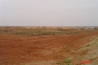
Andamooka ... A 1950’s time warp of an extraordinary little settlement (population: 400) comprised of prefabricated cabins and tin shacks (at first sight, resembling a squatter settlement on the Cape Flats!) each surrounded by huge mounds of spoil from the opal mines on their doorstep. Tourists are advised not to walk backwards…as this place is a rabbit warren of pits and trenches. Definitely not to wander around the mine sites particularly at night, as they stand a good chance of getting shot! These miners are a law unto themselves and proud of it. The caravan park – a raw patch of sticky red earth with a green mat available at some sites and enclosed by a corrugated iron fence greeted us. What had we come to?
As we drove across this little park to our campsite, mud collected up on the wheels leaving deep tracks behind us. No sooner had George got out and unhitched the van than down came the rain, creating an almighty mess and confining us to the caravan for the rest of the day. Sounds dreadful but it all came to form part of a worthwhile experience.
We were given a warm welcome by the caretaker Arthur Harrison, who had heard from his mining partner, Scotsman Dave that we may visit. Next day, our surrounds began to dry out fast and we didn’t have to go “noodling” for opals in the area demarcated for the public as Arthur kindly offered to take us to the opal mine that he works at Gun Gully. The mine was an open pit with a steep roadway down into it for Arthur’s 4x4! At the bottom, an old Bobcat stood inside what resembled a cave. He started up a small generator to power some lights and an electric jackhammer. After explaining where the opals should lie within the different strata that we could see on the back wall or face of the mine, he started chiselling away.
 The jackhammer boy
We both had a go at digging with the jackhammer and in the process got a feel of the hard graft and discomfort involved. The chunks of “rock” that we dug out were surprisingly soft and were crumbled by hand to establish whether there were any opals lurking therein. We unearthed mainly gypsum and found a few slivers of opalised material but NO “parcels” of opals. That afternoon, Arthur gave us a demonstration of how the rainbow matrix or concrete variety of opal are heated and submerged in sugar water to bring out their colour. He brought out a couple of his display cases containing the shaped and polished opals to show us the variations in colour that result and gave us an idea of their value. It was an interesting day. However, the thought of Arthur and his wife, both digging away all day, crouched on their hands and knees, sifting through the spoils in temperatures of 40°C plus, has put both of us clean off the idea of becoming opal miners!
Returning to Port Augusta from the opal fields we passed at least 8 pairs of large wedge-tailed eagles feeding on dead kangaroos beside the Stuart Highway which helped pass the journey hours in this inhospitable landscape despite the blue sky of the day.

Once we’d re-supplied and picked up the Lincoln Highway we found that the weather warning, we’d heard the previous evening, was spot on! Gale winds approaching the Eyre Peninsula soon materialised. Battling against the relentless force of the wind we drove as far as Port Gibbon, passing through clouds of dust blowing off farmer’s fields and the workings of the Iron Duke Mine, and found a car park beside the sea to spend the night. A lovely view overlooking a little bay with waves crashing on the rocky shore not 10m away-makes for a satisfying end to the day.
On the Flinders Highway, which hugs the west coast of the Eyre Peninsula, the name Coffin Bay, caught our attention. This area had so much appeal that we decided to stay the night in the Coffin Bay National Park. The park extends along a 30km peninsula that is thickly covered in a diverse array of coastal vegetation. Although largely comprised of dunes, including some large fields of mobile dunes, the shoreline facing the Southern Ocean contains spectacular wave-swept cliffs and long expanses of wide beaches. Happy to sit still for a while - Lea read her book, while I took a drive to the opposite side of the peninsula. I was so awe struck by the views and the ferocity of the wind and waves that I came back to collect her. The wind was so strong that I could scarcely stand and the spray being generated by the waves crashing against the cliffs below covered my camera and glasses in salt.
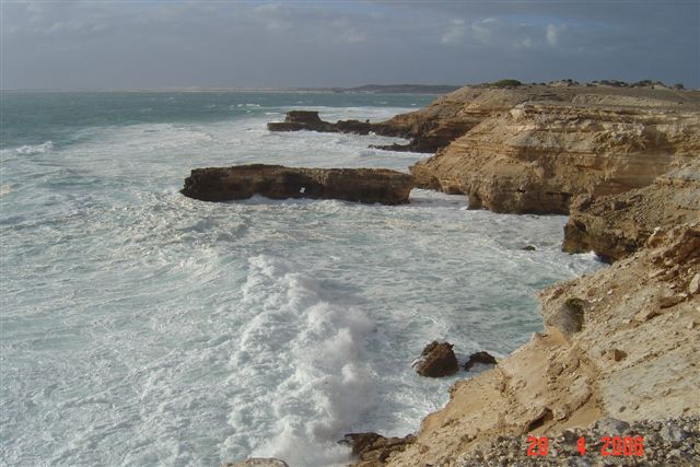
We looked down on what I considered a fearsome sight – huge rollers ceaselessly pounding against the cliffs, foam laced seas seething amongst jagged rocks, cross currents in every direction being formed by the deflection of waves around headlands, submerged reefs and islands. And, way out yonder, according to the notices at the outlook points, great white sharks were said to be lurking.
By the way, after catching sight in my rear view mirror, a pair of Lea’s panties caught on the spare wheel – I realised that I had driven off with the underwear that had been put out to dry on the roof rack! I would have been in deep trouble had they all blown into the ocean.
After a night of rain, we drove out of the park the next morning to the sight of thousands of raindrops glistening amongst the foliage of the bushes. It was good to see a nice calm day had dawned for a change and, in the absence of wind, Skiv literally ate up the miles as she pulled her load steadily northwards. We stopped at a number of lookouts over the Southern Ocean slamming the cliff sides in different directions - memorials to lost men a reminder of its hazards. I got a good photo of our rig parked on the edge of the cliffs with the sea raging below.

After bumping and shaking our way over 40 km. of corrugated gravel roads to Point Labatt Conservation Park we were able to look down onto a beach containing a colony of 40 Australian sea-lions (the country’s most endangered marine mammal). En route we called in to see an oddly shaped outcrop of granite rocks (inselbergs) known as Murphy’s Haystacks. So named, because an Irish agriculturalist passing by in a tourist coach, quipped that the farmer must have been harrowing his fields to have reaped such big haystacks! The tale lived on …
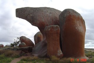
Murphy's Haystacks - pink granite
Nothing like the size of inselbergs found in the Niassa Reserve, Mozambique though.
We are now in a caravan park in Ceduna relaxing quietly for the weekend. Apparently there is a plague of mice along the coastline this season and George easily caught one by hand, releasing it into the dunes. I met a man trapping them humanely within Park facilities BUT then, he leaves them to drown in a bucket of water!
Ahead of us lies the Nullarbor Plain, one of the most unique tracts of unspoilt wilderness on the face of Australia and one of the world’s truly great road journeys. We intend enjoying every inch of the drive and will report back when we reach Perth, 2 000 kms away.
No comments:
Post a Comment